If I had one outdoorsy regret of 2017, it would be that I didn’t get to spend much time outdoors. While I did get to visit New Zealand last year, the summer months were fairly weak in terms of getting outside. 2018 fortunately saw a better start, and I was looking forward to getting out into the hills and mountains in some really, really remote islands.
When I drove out of Tórshavn the first day, parts of the road were still dusted with snow, and the flurries throughout the day made me realize that perhaps trail finding wouldn’t be quite so straightforward. As I followed the road to Norðradalur, it became more evident that even without snow the Faroes’ road network might actually be better than their abundant but elusive hiking trails: road signs are abundant, trail signs not quite as much.

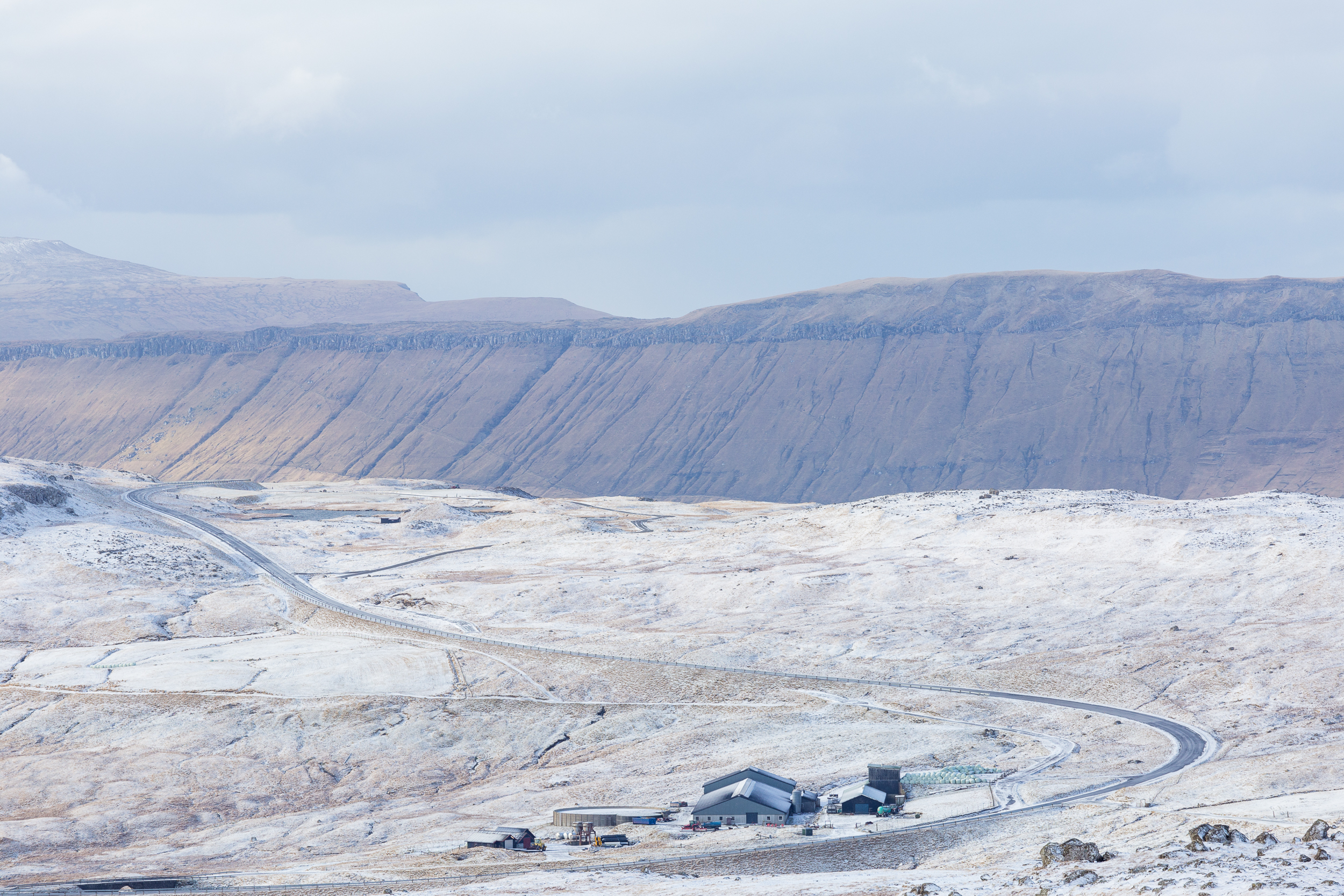
The day I went to Elduvík was more evidence that between whiteouts and up to a foot of snow higher up, hiking might just be a little tough. I was the only car on the road to Elduvík at 8:30 AM, and beneath my tires was a good inch or two of snow.

I left Elduvík in a snowstorm, and although I arrived in Funningur with the best visibility I had had all morning, the roads were still covered. I slowly reached the crest of the pass with much protest from my car, only to look down at a road nearly indistinguishable from the landscape around it.

Indeed, this entire area, which without snow would be a terrific exercise in greyscale, seemed almost washed out in different textures of white. I found the place fascinating, spending a good half hour walking up and down the hill to try to figure out what features I could bring out. Normally, with its hairpin turns the roads above Funningur are a photographer’s delight and offer some of the Faroes’ most familiar images of a village by the sea, but this morning was the first time the realization sunk in that I wouldn’t be hiking much after all.

As I was shooting away, an unexpected visitor brought contrast to the scenes I had just been photographing. Hyundai must have had a push to gain a foothold in the Faroes, as I saw several of their wheel loaders; one was tasked to clearing the roads I had just struggled to drive up. It didn’t, however, clear the road that continues to Eiðisskarð and then onward to Eiði.

Days later, the weather warmed and I thought it might be possible to hike Slættaratindur. However, I was thwarted yet again. When I tried to drive from Eiði back to Funningur, the road was closed well below Eiðisskarð despite being thawed out. Where I had originally looked up at the mountain from its south face, this time I could only look at it from its west face, wondering if some incident had prompted the authorities to close the road when its condition was visibly better than the first time I had seen it.

After a detour around the whole of northern Esturoy, I did manage to get back to Funningur, whose roads (and much of the space around the village) were also completely melted out.

I didn’t continue to Gjógv, but in that direction, too, the handiwork of the civil engineers who designed these roads was apparent. I’m not sure what sort of calculation goes into road gradients and how sharp turns would become to realize a maximum permitted gradient, but all across the Faroes the roads are (narrow but) incredible, gorgeous serpentines. If there weren’t so many sheep and blind corners, these roads would be a lot of fun to drive in a nimble car. My rental car… was tolerable. It helped that I have the same car in Germany, so much of the angst of maneuvering an unknown car on unknown roads that seem impossibly narrow never materialized.

With much of the hiking trails concealed and not particularly welcoming, I spent a good portion of my trip behind the wheel. I ended up putting around 2000 km on the car over about a week, and when I wasn’t making sure I was entering a curve at a safe speed I kept wondering when I could muster up the courage to go on a hike. It seemed no matter where I looked, there was a better vantage point accessible only on foot that I wasn’t at. Despite this, the views were endless, even if they weren’t necessarily taken from an overlook I spent hours hiking to. Double kudos, Faroe Islands.

The amount of driving I did seemed particularly excessive when considering the relative size of the islands. This isn’t a place where all the roads converge on a hub and all circumferential points are connected by some ring road; a good many roads dead end at a village, itself at the edge of an island.

Even on what was arguably my most challenging hike (of a whopping 45 minutes duration), the tiny hamlet of Trøllanes looked like it could be ready to slide into the water. The sheep evidently couldn’t have been less bothered.

One of my favorite shots of the entire trip was along the road to Æðuvik. It’s possible to hike from here to Nes, and apart from being the southernmost inhabited village on Esturoy it is also allegedly notorious for being at the whims of whatever ocean storms are brewing. The day I went was only overcast, but despite not hiking at all that day I’m pretty sure licked my lips when I saw the road I’d be taking. It wasn’t too far into the trip that I understood that I was trading hiking for driving, but surprisingly given my opening statement of a particular 2017 regret, I was okay with it here. It might have been the trip two years ago to Scotland that taught me a little bit about living with the hand that nature deals, but on this trip I was simply happy to have been in such an environment in a rather low-tourism season. I may have missed the northern lights, and I may have spent the majority of my time on foot in the city of Tórshavn rather than in the mountains, but I’d argue the mystique of the Faroes was only enhanced thus, not diminished.

One of my last stops in the car was to Viðareiði, the northernmost city on Viðoy and the departure point for hikes to Enniberg, the northernmost point in the Faroes and among the highest sea cliffs in the world. It was somehow fitting that a revered hiking and climbing spot in the Faroes would be one so inaccessible to me this trip, as if in mockery of my feeble attempts to explore the Faroes under my own power. Here, though, with iffy weather and 700 m drops into the ocean, I had no regrets staying safely inland.

The question I couldn’t quite answer at the end of my trip was whether I’d go back to the Faroes, either for proper hiking or just to explore whatever I couldn’t the first time (after all, I’ve only been to half the islands!). The landscape is stunning. In this sense, it reminded me of Scotland; it’s wild, untamed, and raw. For photography, it’s empowering, as there are opportunities at every turn. It does mean, however, that for colorful sunrises or sunsets or straightforward hiking in daylong clear weather that there is some amount of luck needed. Socially, that the islands have thrived is not necessarily surprising. The Faroese I ran into were always happy to help answer questions, and beneath their friendliness I thought I detected a genuine curiosity of what would bring tourism to their little enclave. It’s this thought that scares me most about the islands. Iceland and Norway have both become popular destinations for getaways and photographic excursions alike, and I’m not sure how the infrastructure of the Faroe Islands is set up to handle that much traffic. Their roads are in impeccable condition (some tunnels excepted; some of the smaller ones are a bit pothole-ridden), and their mobile network is the best I’ve ever used. But I got to see the islands in their low season; I can imagine some vantage points or junctions completely overwhelmed should the tourism industry there blossom as heartily as the ones its far-east and far-west neighbors have experienced.
Writing these posts, then, was a bit of a conundrum. On the one hand, I can share my snapshot of what my experiences in the Faroes were, but on the other, every post like this one encourages the touristic exploitation of a land whose physical features might not be prepared for what will come. Mykines is already experiencing the burden of excessive tourism, and the thought of even just hundreds of people making the trek to the Kallur lighthouse is a bit daunting; the parking lot has spaces for maybe a dozen cars. Of course, I am glad I went, even if my trip was less on foot than I had hoped. If nothing else, I left that much more wilderness untouched and unfettered for future visitors to explore.

[…] dilemma for me was not new; I had commented on it after my trip to the Faroes, too, and my laments about Zermatt crowds are based on preservation […]